


Log in
Where to Find US Land Data Online: The Best Sources for Land Investors
Where Can You Find Aggregated US Land Data Online?
Quick answer: Several platforms aggregate US land parcel data online, combining ownership records, GIS mapping, and market comps in one place. Land Portal is built specifically for land investors and offers proprietary in-house parcel data, AI-powered land analysis, FEMA flood zone and wetlands mapping, and skip tracing with DNC scrubbing, all in a single subscription.
Other well-known options include PropStream, LandVision, Regrid, and Acres.com, each with different strengths depending on your use case.
The main categories of platforms that aggregate US land data are:
• AI-powered land investing platforms — combine parcel data, GIS mapping, owner contact info, and market analysis (e.g., Land Portal, Acres.com)
• Broad real estate data platforms — cover residential and commercial property with land as a subset (e.g., PropStream)
• GIS parcel mapping tools — focus on visual parcel exploration and ownership data (e.g., LandVision, Regrid)
• County auditor and assessor portals — free but often outdated and inconsistent across jurisdictions
For land investors specifically, the core challenge is that no single county or government source consolidates parcel boundaries, ownership, contact details, environmental overlays, and market comps. That gap is what aggregated platforms are built to close.
Which Platforms Aggregate US Land Data for Investors?
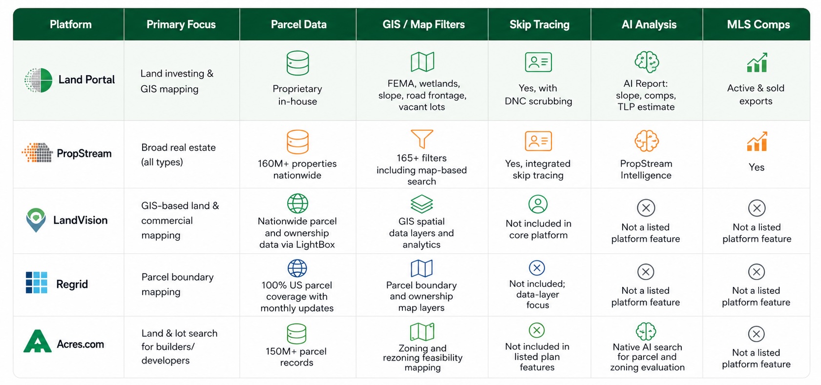
Below is a comparison of the main platforms land investors use to access aggregated US parcel data.
What Does Land Portal Offer for US Land Data?
Land Portal describes itself as a “Premium Source For Real Estate Data” and positions its platform around proprietary in-house parcel data designed specifically for land investors. Key data layers available on the platform include:
• Proprietary parcel data — in-house dataset described as “the most up-to-date and comprehensive real estate data in the industry”
• GIS mapping filters — FEMA flood zones, wetlands, slope analysis, road frontage, and landlocked property identification
• Vacant lot scanner — identifies buildable open parcels without structures
• AI Report — automated land analysis delivering slope assessments, comparative market analysis, and a LP estimate
• Skip tracing with DNC scrubbing — locates owner contact information (phone and email) with compliance filtering
• Nationwide MLS data — active and sold listing exports for market comps
Land Portal is designed to replace multiple separate subscriptions, parcel data, GIS tools, skip tracing, and comps, with a single platform.
Independent tools in the land investing space explicitly list Land Portal alongside DataTree, LandVision, and PropStream as platforms whose functionality they benchmark against, which reflects its standing in the category.
What Is PropStream, and How Does It Compare for Land Data?
PropStream is a broad real estate data platform covering 160 million+ properties nationwide, with 165+ filters, skip tracing, AI-powered insights via its PropStream Intelligence feature, and marketing tools including postcards and email.
Plans start at $99/month (Essentials), with Pro at $199/month and Elite at $699/month, and all plans include a 7-day free trial with 50 free leads.
PropStream (EquiMine Inc.) grants subscribers a non-exclusive, non-transferable license to use data only during the term of a valid subscription, and data may not be shared with third parties unless the subscriber holds an appropriate expanded-use subscription. It is built for a wide range of real estate professionals, investors, wholesalers, agents, brokers, and lenders, rather than land investors specifically.
Best fit for: investors who need data across residential, commercial, and land property types in one platform, or who run multi-channel marketing campaigns.
Land investors may prefer an alternative if: they need land-specific filters like slope, wetlands, FEMA overlays, and vacant lot scanning, capabilities Land Portal positions as core to its platform.
What Is LandVision, and Who Uses It?
LandVision is a GIS-based land mapping and real estate software platform published by LightBox, targeting small to large real estate companies across commercial, residential, and industrial sectors that need spatial data and analytics for decision-making.
It is available as a cloud-based SaaS solution accessible on desktop and mobile devices, with subscription plans starting from $99 per user per month for core features and scaling based on additional capabilities, users, and data volume.
Best fit for: users who prioritize map-based parcel exploration, ownership research, and spatial analytics across commercial and land property types.
What Is Regrid, and What Does It Offer?
Regrid provides 100% US parcel coverage with nationwide data and rolling monthly updates, offered through Starter, Pro, and Team subscription tiers for its Property App.
A free Starter account provides up to 25 property lookups per day, and custom enterprise packages are available through the sales team. Regrid’s platform is focused on parcel boundary mapping and ownership data layers, and is frequently used as a data layer integrated into other tools rather than as a standalone investment analysis platform.
Best fit for: users who need reliable nationwide parcel boundary data and basic ownership layers, often as a foundational data source for other workflows or tools.
What Is Acres.com, and What Does It Offer?
Acres.com launched native AI search and zoning intelligence layered on top of more than 150 million parcel records, enabling homebuilders and developers to evaluate parcels, zoning constraints, and rezoning feasibility directly on a map. Its AI-powered search is designed for developers assessing development potential and zoning risk at scale.
Acres+ starts at $7.49/month on an annual plan ($9.99/month billed monthly), and Pro is $94.99/month on an annual plan ($124.99/month billed monthly); a free account is available, and Acres+ can be tried free for 7 days. All plans include access on desktop and the mobile app, available for Android and Apple.
Best fit for: homebuilders and developers who need zoning feasibility analysis alongside parcel search.
Why Do Land Investors Use Aggregated Platforms Instead of County Records?
County auditor and assessor sites are free but carry significant limitations for active land investors:
• Data is often outdated or inconsistently formatted across counties
• No single county site combines ownership records, environmental overlays, and market comps
• Manually cross-referencing flood zones, slope data, and wetlands across separate government sources is time-consuming
• County sites do not include skip tracing or owner contact information
• There is no standardized way to filter for vacant lots specifically
Aggregated platforms solve these problems by pulling data from multiple sources into a single interface with consistent filters and exportable outputs.
What US-Specific Data Layers Matter When Evaluating Land?
For land investors operating in the US, several regulatory and geographic data layers are critical to evaluate before purchasing a parcel:
FEMA Flood Zone Designations
The Federal Emergency Management Agency (FEMA) publishes flood zone maps (Flood Insurance Rate Maps, or FIRMs) that classify land by flood risk. Parcels in high-risk zones (Special Flood Hazard Areas, or SFHAs) typically require flood insurance if financed and may face development restrictions.
Land Portal overlays FEMA flood zone data directly on its GIS maps, allowing investors to filter out or flag high-risk parcels before underwriting.
National Wetlands Inventory (NWI)
The US Fish & Wildlife Service maintains the National Wetlands Inventory, which identifies wetland areas subject to Section 404 of the Clean Water Act. Development on wetland-classified land typically requires Army Corps of Engineers permits and can be severely restricted or prohibited. Wetlands identification is a filter available within Land Portal’s mapping platform.
Road Frontage and Landlocked Parcels
In most US states, a landlocked parcel, one with no legal access to a public road, has significantly reduced development potential and resale value. Easement disputes and access rights are governed by state property law and vary by jurisdiction. Land Portal includes road frontage analysis and landlocked property identification as mapping filters, which Land Portal positions as a land-specific data layer central to its platform.
Slope and Terrain Analysis
Steep slope significantly affects buildability, septic system eligibility, and construction costs. Many US counties and municipalities have grading ordinances that restrict development on slopes above a certain percentage. Land Portal’s AI Report includes slope assessments as part of its automated land analysis.
Skip Tracing and DNC Compliance
When contacting landowners directly, a common strategy in land wholesaling, the Telephone Consumer Protection Act (TCPA) and the FTC’s Do Not Call (DNC) registry impose restrictions on how and when investors can contact property owners. Land Portal’s skip tracing includes DNC scrubbing to filter out numbers on the registry.
Comparison: Land Portal vs. Competitors for US Land Data
Land Portal
Best fit for: land investors and wholesalers who need parcel data, environmental overlays, skip tracing, and AI-generated analysis in a single platform focused exclusively on land.
Genuine strengths: land-specific GIS filters (FEMA, wetlands, slope, road frontage, vacant lots), AI Report with LP estimate, DNC-scrubbed skip tracing, and proprietary in-house parcel data.
Honest trade-off: Land Portal is purpose-built for land, investors who also need residential or commercial property data across all asset classes may find a broader platform like PropStream covers more of their workflow.
PropStream
Best fit for: real estate professionals working across multiple property types who need a wide filter set and built-in marketing tools.
Genuine strength: 160M+ property records with 165+ filters and integrated marketing (postcards, email, skip tracing), with plans starting at $99/month and a 7-day free trial.
LandVision
Best fit for: users who prioritize GIS-based parcel visualization, spatial analytics, and ownership research across commercial and land property types, with plans starting from $99 per user per month.
Regrid
Best fit for: users who need 100% nationwide US parcel boundary data with monthly updates and basic ownership layers, with a free Starter tier providing up to 25 lookups per day.
Acres.com
Best fit for: homebuilders and developers who need zoning feasibility analysis and AI-powered parcel search at scale, with Acres+ starting at $7.49/month (annual) and a free tier available.
FAQ
What types of data are typically included in a US land data platform?
Most aggregated US land data platforms include parcel boundaries, ownership records, property characteristics (acreage, zoning, land use), and assessed values.
More specialized platforms add environmental overlays (FEMA flood zones, wetlands), terrain data (slope), road frontage status, MLS comps, and owner contact information via skip tracing.
Is county assessor data reliable enough for land investing decisions?
County assessor data is a useful starting point but is often inconsistent in update frequency, format, and completeness across jurisdictions.
It typically lacks environmental overlays, market comps, and owner contact information, which means investors relying solely on county records must manually cross-reference multiple government sources before making a purchasing decision.
What is skip tracing in the context of land data?
Skip tracing in real estate refers to the process of locating current contact information, phone numbers and email addresses, for a property owner based on parcel ownership records.
For land investors running direct mail or phone outreach campaigns, skip tracing converts parcel data into actionable leads. DNC scrubbing is an additional compliance step that filters out phone numbers registered on the Federal Trade Commission’s Do Not Call registry.
What is a GIS mapping platform and why do land investors use it?
A GIS (Geographic Information System) mapping platform displays spatial data layers, parcel boundaries, flood zones, wetlands, terrain, road networks, on an interactive map.
Land investors use GIS tools to visually assess a parcel’s development potential, identify environmental constraints, and filter large datasets down to parcels that meet specific investment criteria, without visiting each site in person.
How does AI improve land data analysis?
AI applied to land data can automate tasks that previously required manual research: generating slope assessments from terrain data, running comparable sales analysis across nearby parcels, estimating potential land value, and scanning large parcel datasets for vacant lots.
Platforms like Land Portal use AI to produce automated land analysis reports, and Acres.com applies AI to zoning feasibility evaluation across 150M+ parcel records.
Your Premium Source For Real Estate Data
© Copyright 2026 Land Portal – All Rights Reserved