

Log in
Raw Parcel Data vs. Land Investing Software: What's the Difference?
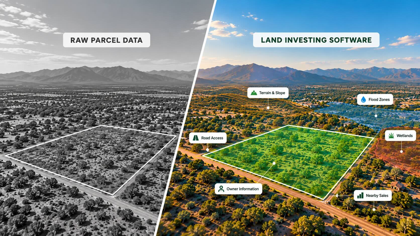
County property records can tell you who owns a parcel, where it’s located, how much acreage it contains, and what the county has assessed it for.
But that information alone doesn’t tell you whether the property is a good investment.
Does it have road access? Is it affected by wetlands or flood zones? What are similar properties actually selling for?
These are the questions land investors need to answer before making an offer.
Raw parcel data is a useful starting point, but it doesn’t provide the full picture. Land investing software brings property records together with market research, comparable sales, mapping, and land-specific filters to help investors make more informed decisions.
Here’s what raw parcel data includes, what it leaves out, and when dedicated land investing software becomes valuable.
What Is Raw Parcel Data?
Raw parcel data is the basic property information maintained by county assessors and other local government offices. For example, the Clark County Assessor’s property search provides access to publicly available property records.
Depending on the county, these records typically include:
• Assessor’s Parcel Number (APN) or Property ID: A unique identifier for the property.
• Owner information: Owner name and mailing address.
• Property details: Acreage, location, and land use classification.
• Assessed value: The value used for property tax purposes.
• Tax information: Property taxes and available payment history.
• Parcel boundaries: Approximate property outlines displayed on county maps.
These records are primarily maintained for assessment, taxation, and other government purposes, not specifically for land investors.
Because counties maintain their own records, the information available, how it’s organized, and how frequently it’s updated can vary.
That may not be an issue when researching one property. But when you’re evaluating hundreds of parcels across multiple counties, working with separate county records becomes much more time-consuming.
What Does Raw Parcel Data Leave Out?
County property records provide valuable information, but several important details aren’t always included.
Parcel Boundaries Don’t Confirm Legal Access
A county parcel map can show the approximate boundaries of a property, but it doesn’t necessarily confirm legal or physical access.
A parcel might appear to touch a road but still have access issues. Other properties may depend on private roads or recorded easements.
Land Portal’s Road Frontage AI and Landlocked filters help investors identify potential access concerns early.
However, legal access and property boundaries may still require verification through recorded documents, title research, or a survey.
Wetlands and Flood Zones Require Additional Research
Wetlands and flood zones can affect a property’s usability, development potential, and resale value.
Basic county parcel records don’t always provide this information.
Land Portal includes Wetlands and FEMA flood zone filters, along with mapping overlays that help investors identify where these conditions may affect a parcel.
These tools are useful for screening properties, but they don’t replace professional due diligence. As the U.S. Fish and Wildlife Service explains, mapped wetlands don’t necessarily establish the extent of federally regulated wetlands.
Assessed Value Isn’t the Same as Market Value
A property’s assessed value is used for tax purposes. It doesn’t necessarily reflect what someone would pay for that land today.
As the California State Board of Equalization explains, assessed values and current market values can differ.
To estimate market value, investors need to review recent comparable sales and account for differences in acreage, location, access, terrain, and other property characteristics.
Land Portal’s comping tools help investors evaluate sold land and compare pricing using actual market activity rather than relying on county assessments.
Property Records Don’t Always Include Owner Contact Information
County property records typically include an owner’s name and mailing address, but they usually don’t provide phone numbers or email addresses.
For example, the Sacramento County Assessor maintains mailing address information for property owners, which is different from providing the contact details investors may need for outreach.
That’s where skip tracing comes in.
Land Portal offers individual and bulk skip tracing to help investors find available owner contact information. The platform also includes DNC (Do Not Call) and litigator scrubbing to help screen phone numbers before outreach.
Raw Parcel Data vs. Land Investing Software
The main difference is how much information you have available when researching a potential deal.
Raw parcel data provides the basic property record. Land investing software combines that information with additional research and marketing tools.
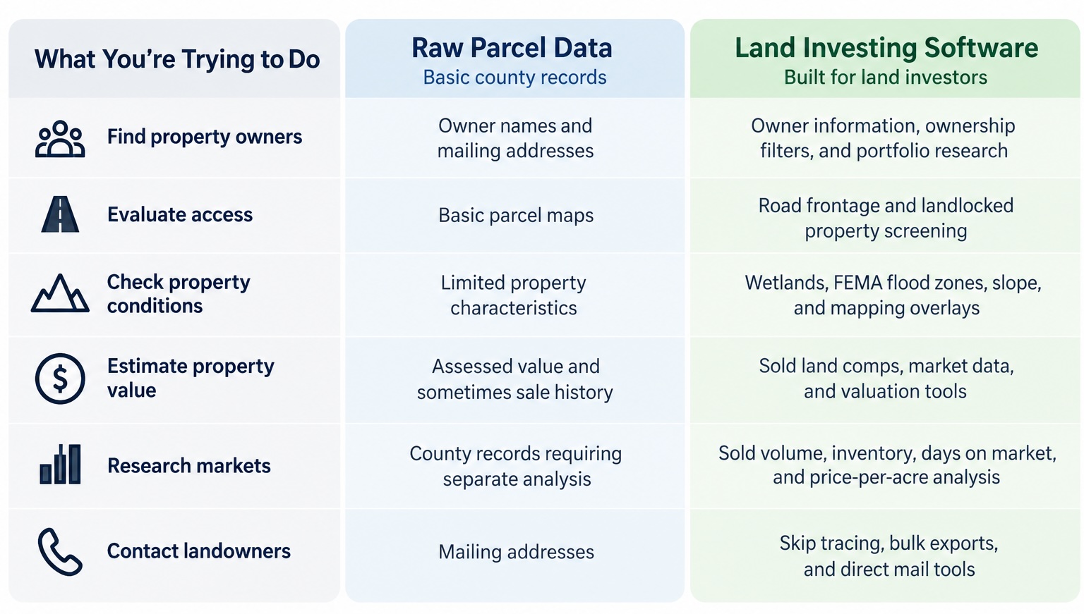
The goal isn’t simply to access more property records. It’s to identify properties that fit your buying criteria and have enough information to evaluate them before making an offer.
How to Turn Property Data Into a Targeted Land Investing List
Having access to thousands of property records doesn’t automatically mean you have thousands of good leads.
Here’s how land investors can narrow that data into a more targeted acquisition list.
1. Research the Market
Before pulling a list, look at sold activity, active inventory, days on market, and price per acre within your target acreage range.
This helps determine whether there’s consistent buyer demand for the type of land you plan to purchase.
2. Filter for the Right Properties
Narrow your search using acreage, ownership characteristics, vacant land status, road frontage, wetlands, slope, and other land-specific criteria.
Land Portal’s filters help remove properties that don’t fit your investment strategy before you spend money on outreach.
3. Screen for Potential Issues
Review parcel boundaries, road access, terrain, wetlands, flood zones, and other conditions that could affect usability or resale.
Investigate any concerns that require additional verification.
4. Evaluate Comparable Sales
Research recent sold properties with similar acreage, location, access, and characteristics.
Land Portal’s comping tools and LP Estimate can help establish a starting point for valuation, but investors should still review the comps and account for property-specific differences.
5. Build Your List and Contact Owners
Once you’ve identified properties worth pursuing, you can export your list, skip trace owners, or prepare a direct mail campaign.
Land Portal connects these steps, allowing investors to move from market research to owner outreach within the same platform.
When Is Raw Parcel Data Enough?
If you’re researching a single property, checking ownership information, or reviewing county tax records, raw parcel data may be all you need.
You can also build a land investing business using separate county databases, mapping tools, and research platforms.
But as you begin evaluating more properties and researching multiple markets, gathering information from different sources becomes increasingly time-consuming.
Dedicated land investing software simplifies that process by bringing property data, market research, mapping, and comparable sales together.
How Land Portal Brings Property Research Together
Land Portal is built specifically for land investors, combining nationwide property data with the tools needed to research markets, evaluate parcels, and contact owners.
With Land Portal, investors can:
Research markets: Compare sold activity, inventory, days on market, and price per acre.
Find properties: Use land-specific filters such as Vacant Land AI, Road Frontage AI, wetlands, slope, and ownership criteria.
Evaluate land values: Review comparable sales and generate AI-powered comp reports with LP Estimate.
Check property conditions: Use parcel boundaries, contour lines, wetlands, FEMA flood zones, and other mapping layers.
Contact owners: Access ownership information, skip trace contacts, export lists, and send direct mail through the Mail Center.
Instead of piecing together information from multiple sources, investors can research a market, find properties that meet their criteria, evaluate potential deals, and build targeted acquisition lists in one place.
The Bottom Line
Raw parcel data is valuable, but it’s only one part of evaluating a land deal.
Understanding the market, reviewing comparable sales, screening property conditions, and identifying the right owners to contact are just as important.
Land Portal brings those tools together so investors can spend less time gathering information and more time finding and evaluating opportunities.
Explore Land Portal’s plans and start your 7-day free trial to research your next market or property.
Frequently Asked Questions
Is county parcel data accurate enough to buy land?
County parcel data is a useful starting point, but investors should also verify access, boundaries, zoning, title, and other property conditions before purchasing. Additional due diligence may be necessary depending on the property.
Can I use assessed value to price an offer on land?
Assessed value is used for property tax purposes and may not reflect current market value. Recent comparable land sales provide a better starting point for determining an offer price.
Does a wetland layer mean a parcel cannot be built on?
Not necessarily. Wetlands mapping identifies areas that may require further investigation. Whether a property can be developed depends on applicable regulations, site conditions, and other factors.
Why doesn’t parcel data include the owner’s phone number?
County property records are primarily maintained for assessment and taxation. They typically include mailing addresses but not personal phone numbers or email addresses. Skip tracing can help identify additional contact information.
Is parcel data the same in every U.S. county?
No. Available property information, formatting, and update schedules vary by county. Nationwide property data platforms help bring these records into a more consistent search experience.
Your Premium Source For Real Estate Data
© Copyright 2026 Land Portal – All Rights Reserved