

Log in
What to Look for in Land Data: 10 Things to Check Before Buying
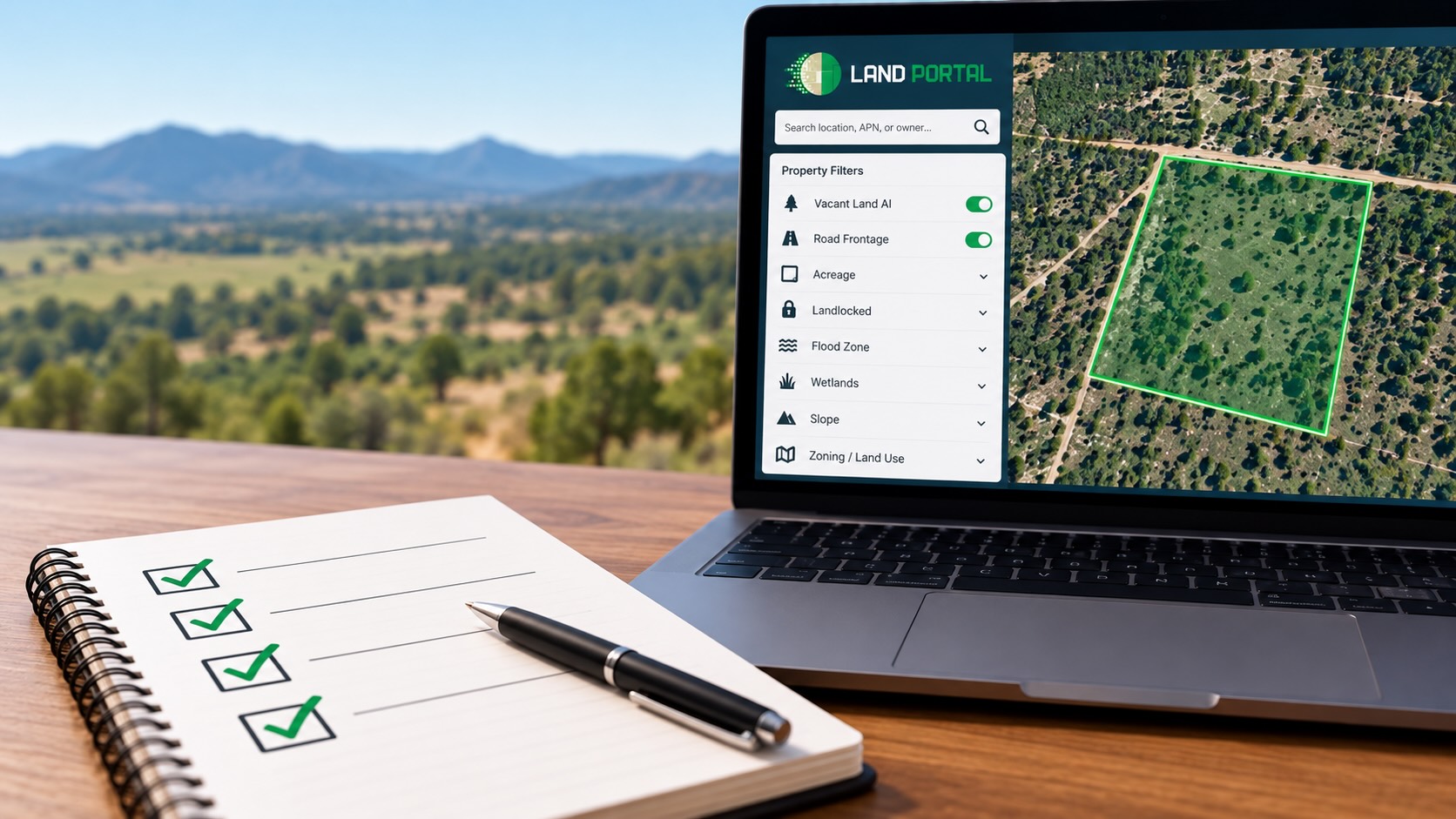
When you’re researching vacant land, having access to property data is essential. But just because information appears in a property database doesn’t mean it’s complete or up to date.
Ownership records can change. Parcel boundaries may be approximate. And important details like legal access, zoning, and wetlands often require additional verification.
Good land data helps you find and evaluate opportunities. Knowing what to verify helps you avoid costly mistakes.
Whether you’re researching a single property or building a list of potential land deals, here are 10 important things to check and where to verify the information.
10 Important Land Data Fields to Check
Not every property detail comes from the same source. County offices maintain ownership and tax records, while agencies like FEMA and the U.S. Fish and Wildlife Service provide environmental mapping data.
Understanding where this information originates can help you recognize when something needs a closer look.
1. Parcel Boundaries
Parcel maps help investors locate properties and understand their approximate shape and size.
However, GIS parcel boundaries are not the same as a legal survey. County mapping systems are generally intended for assessment and reference purposes.
The West Virginia Property Viewer, for example, explains the distinction between mapped parcel information and legally recognized property measurements.
When boundaries are important to a purchase decision, review the recorded plat or deed and obtain a survey when necessary.
2. Property Acreage
Acreage is one of the most important factors in land valuation, especially when comparing properties by price per acre.
But the acreage displayed on a parcel map may be calculated using GIS measurements rather than taken directly from the recorded deed.
Small differences may not matter during an initial property search. Larger discrepancies deserve additional attention.
What to check: Compare the platform’s acreage with the deeded acreage and investigate significant differences before purchasing.
3. Current Property Owner
Accurate ownership information is essential when contacting landowners or preparing purchase offers.
Ownership records aren’t always updated immediately after a property changes hands.
For example, Snohomish County, Washington explains that updating assessor ownership information after a recorded sale can take several weeks.
If you’re researching a recently sold property, check the latest recorded deed to confirm the current owner.
4. Owner Mailing Address
Many vacant landowners live outside the county or state where their property is located.
That makes the owner’s mailing address especially important for investors using direct mail to find off-market deals.
County records provide a useful starting point, but mailing addresses can become outdated when owners move.
The USPS NCOALink service helps eligible mailing providers identify certain address changes.
What to check: Confirm that mailing addresses are reasonably current and understand how your mailing provider handles address updates.
5. Property Sales History
Previous sales can provide valuable context when evaluating land values.
However, it’s important to distinguish between an actual completed sale and a property’s listing price.
An asking price represents what a seller hopes to receive. A recorded sale provides evidence of a completed transaction, although some transfers may not reflect an ordinary market sale.
Look for transaction dates, recorded sale information, and relevant comparable properties.
When estimating value, prioritize recent sold land comps with similar acreage, location, access, and property characteristics.
6. Zoning and Land Use
Zoning determines which uses may be permitted on a property, making it especially important for investors targeting residential lots, subdivisions, or development opportunities.
Online zoning maps can help identify a property’s general classification, but they may not reflect every recent change.
Monona County, Iowa, for example, advises users to verify zoning information with the appropriate county office.
What to check: Confirm current zoning and applicable restrictions with the local planning or zoning department before relying on a particular intended use.
7. FEMA Flood Zones
Flood zones can affect how land is used, developed, financed, and insured.
Property research platforms may display FEMA flood zone overlays, allowing investors to identify potential concerns during their initial search.
For verification, use FEMA’s National Flood Hazard Layer, which provides access to official flood hazard mapping information.
Remember that mapped flood zones are a screening tool. Site-specific conditions and additional due diligence may still be necessary.
8. Wetlands
Wetlands can affect a property’s development potential, particularly when grading, filling, or construction is involved.
The U.S. Fish and Wildlife Service’s National Wetlands Inventory provides mapping data that can help identify potential wetland areas.
However, wetlands maps are not a substitute for a professional wetland delineation or regulatory determination.
What to check: Review available wetlands mapping and investigate further when mapped wetlands overlap with the areas you intend to use.
9. Road Access
Road access is one of the most important considerations when evaluating vacant land.
A property might appear to touch a road on a map without having confirmed legal access. Other parcels may depend on private roads or recorded easements.
Land investing software can help identify road frontage and potentially landlocked properties, but these filters cannot establish legal access on their own.
A Utah property rights advisory opinion illustrates why documented access rights can matter when seeking building permits.
What to check: Verify access through public road records, recorded easements, deeds, and title research as appropriate.
10. Slope and Soil Conditions
Terrain and soil characteristics can affect a property’s usability and potential development costs.
Slope data helps investors identify steep areas, while soil information can provide insight into drainage, soil types, and other site characteristics.
The USDA Web Soil Survey provides soil information for land throughout the United States.
These tools are useful for initial research, but construction, septic systems, and other development plans may require professional site evaluations and testing.
Quick Reference: Where to Verify Land Data
Use this table when reviewing a property or comparing the information available through different land data platforms.
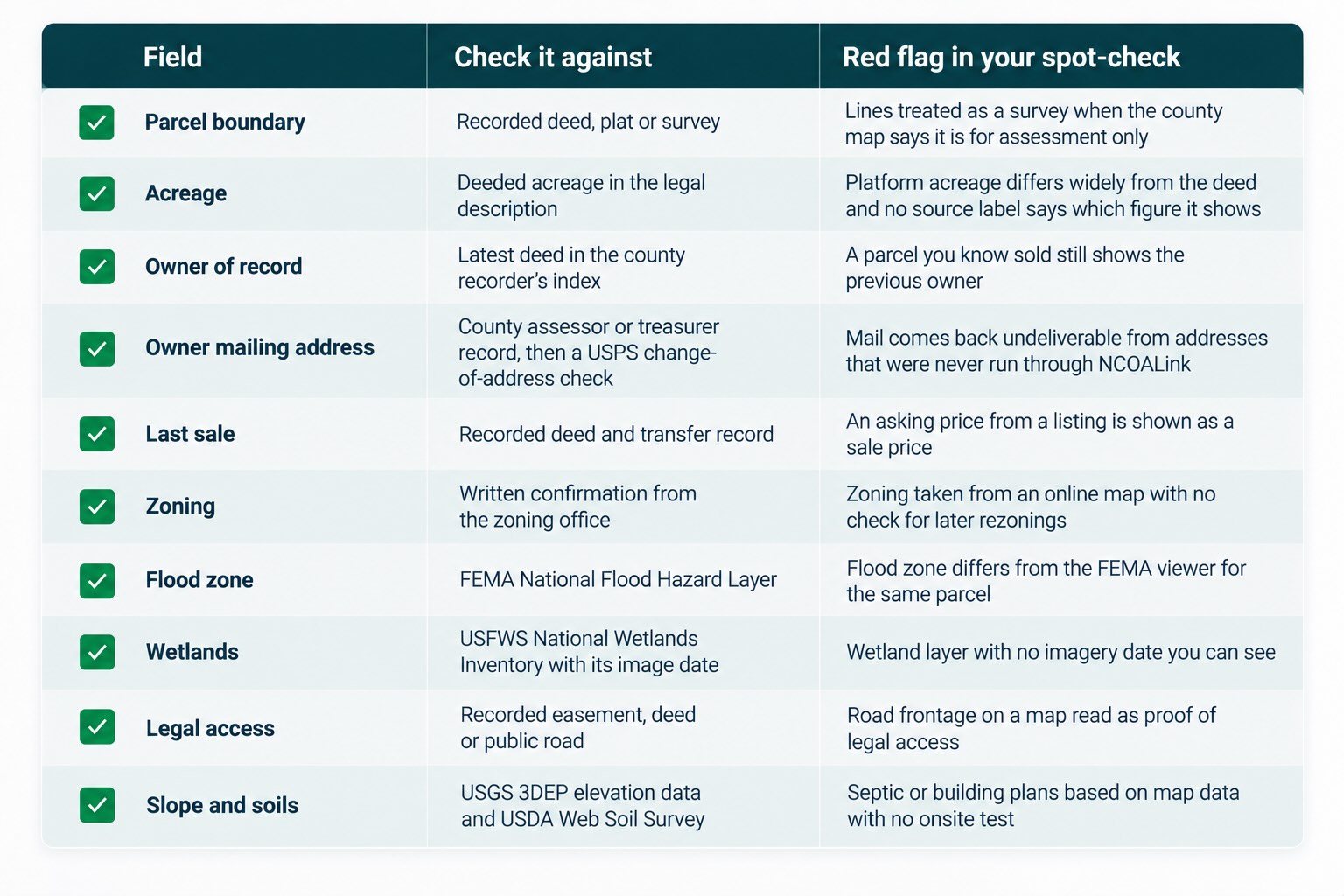
The goal isn’t to independently verify every detail on every property you search.
It’s to know which information needs additional confirmation before you make a significant financial commitment.
How to Check the Accuracy of a Land Data Platform
Before relying heavily on a property data platform, it’s worth testing it against properties you’re already familiar with.
Here’s a simple way to do that:
1. Choose a few properties. Include parcels with different characteristics, such as a recently sold property, a landlocked parcel, and one affected by a flood zone.
2. Review the platform’s information. Check ownership, acreage, sales history, access, and environmental layers.
3. Compare official records. Use county property records, recorded deeds, FEMA maps, and other relevant sources.
4. Investigate discrepancies. Determine whether differences come from outdated records, mapping limitations, or other factors.
5. Test another county. Property records and reporting practices vary by location, so accuracy in one market doesn’t guarantee the same results everywhere.
This process can help you understand both the strengths and limitations of the data you’re using.
When Is Land Data Enough, and When Do You Need Additional Due Diligence?
Land data platforms are especially valuable during the early stages of finding and evaluating properties.
You can use them to research markets, filter parcels, compare sales, and identify potential concerns before spending time on deeper investigations.
But once you’re seriously considering purchasing a property, certain details deserve additional verification. For example, you may need to confirm legal access, review title records, obtain a survey, verify zoning, or investigate environmental conditions.
Think of property data as your first level of research, not a replacement for due diligence.
The more a particular detail affects the property’s value or your intended use, the more important it becomes to verify it before closing.
How Land Portal Helps Investors Research Property Data
Land Portal combines nationwide property and ownership data with tools designed specifically for land investors.
Instead of researching each property through multiple county websites and mapping services, investors can access property information and land-specific filters in one platform.
Some of the key features include:
Property and ownership information: Research parcel details, acreage, ownership, mailing addresses, and available sales history.
Vacant Land AI: Identify properties likely to be vacant.
Road Frontage AI and Landlocked filters: Screen properties for potential access concerns.
Wetlands and FEMA filters: Identify parcels affected by mapped environmental conditions.
Slope Analysis and mapping overlays: Evaluate terrain and other physical property characteristics.
Market Research and LP Estimate: Review market activity, comparable sales, and AI-powered property estimates.
These tools help investors narrow large property searches into more targeted lists and identify properties worth investigating further.
They don’t replace recorded deeds, surveys, title research, or professional site evaluations when those are necessary.
The Bottom Line
Reliable land data is the foundation of good property research, but no single dataset tells you everything about a parcel.
Ownership, acreage, sales history, zoning, access, and environmental conditions all play a role in determining whether land is worth pursuing.
The key is knowing what information to look for, where it comes from, and which details require further verification.
With the right research tools, you can identify potential opportunities faster while focusing your due diligence on the properties that matter most.
Explore Land Portal’s plans and start your 7-day free trial to research properties, compare markets, and evaluate land with greater confidence.
Frequently Asked Questions
What is the most important information to check in land data?
Ownership information is particularly important when contacting sellers or making offers. However, acreage, legal access, zoning, and comparable sales can be just as critical depending on your investment strategy.
Is GIS-calculated acreage accurate enough to price land?
GIS acreage can be useful for preliminary research, but it may differ from deeded acreage. Investors should investigate significant discrepancies and verify property measurements when they could affect a purchase decision.
How often do flood zone and wetlands maps change?
Update schedules vary by agency and dataset. FEMA incorporates updated flood hazard information, while the U.S. Fish and Wildlife Service periodically updates its wetlands inventory. Check the relevant agency’s information when evaluating a specific property.
Does road frontage on a parcel map mean the land has legal access?
No. A parcel appearing to touch a road doesn’t automatically establish legal access. Investors should verify access rights through appropriate deeds, easements, title records, or other official documentation.
Can you rely on an online zoning map?
Online zoning maps are useful for initial research, but they may not reflect every recent change or restriction. Contact the local zoning department to confirm current requirements before making a purchase based on a particular intended use.
Your Premium Source For Real Estate Data
© Copyright 2026 Land Portal – All Rights Reserved