

Log in
5 Best Regrid Alternatives for Land Investors (2026)
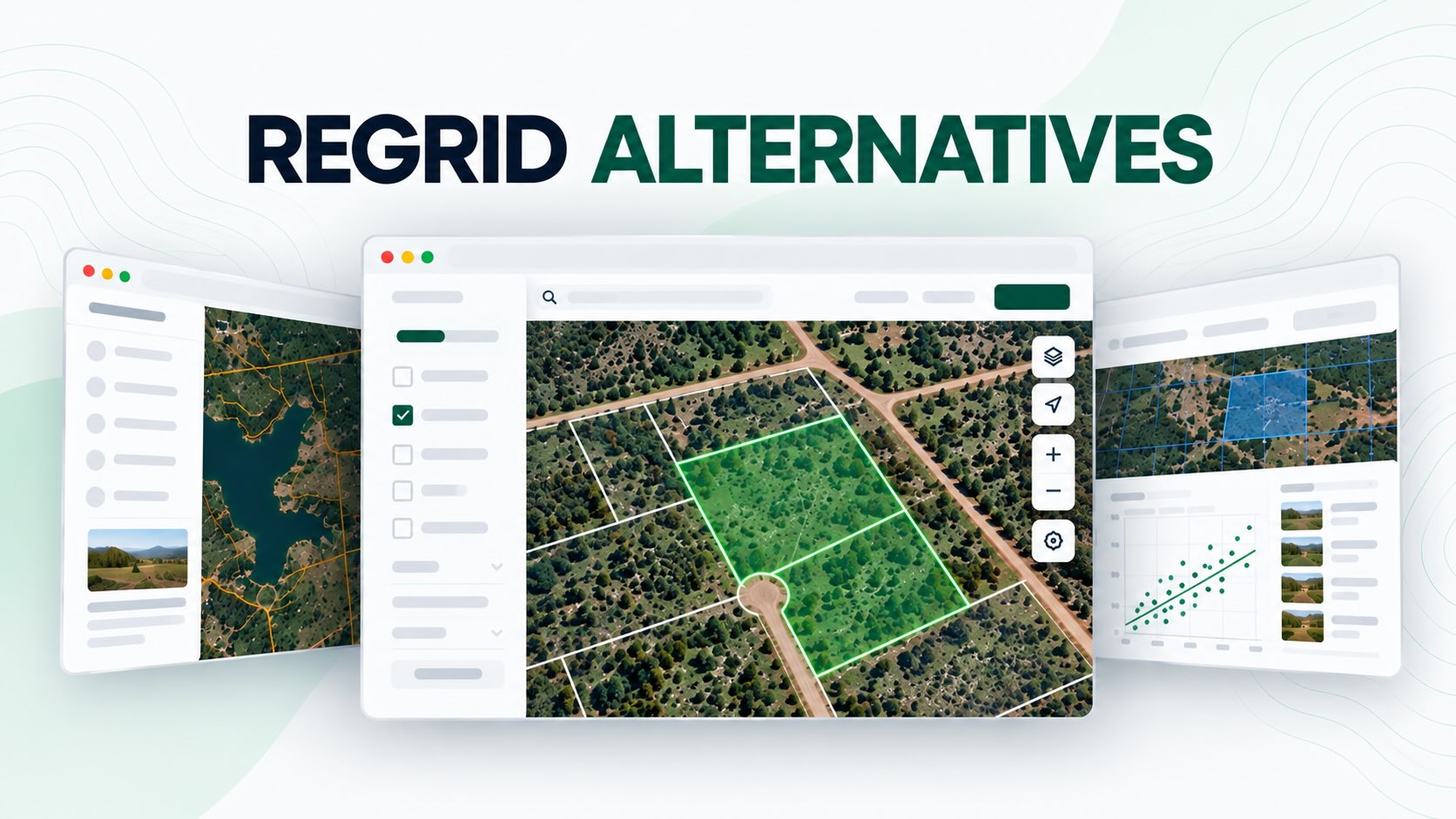
Regrid is a useful platform for viewing parcel boundaries, researching ownership information, and exploring property data across the United States.
But depending on how you invest in land, parcel maps might only be the starting point.
Finding a property is one thing. Determining whether it’s worth buying, researching comparable sales, and contacting the owner are entirely different parts of the process.
That’s where other land mapping and investing platforms can offer additional value.
Some Regrid alternatives focus on finding off-market land deals. Others specialize in property mapping, on-site parcel research, comparable sales, or agricultural land.
Here are five Regrid alternatives worth considering in 2026, what each does best, and how to decide which platform fits your needs.
Best Regrid Alternatives: Quick Comparison
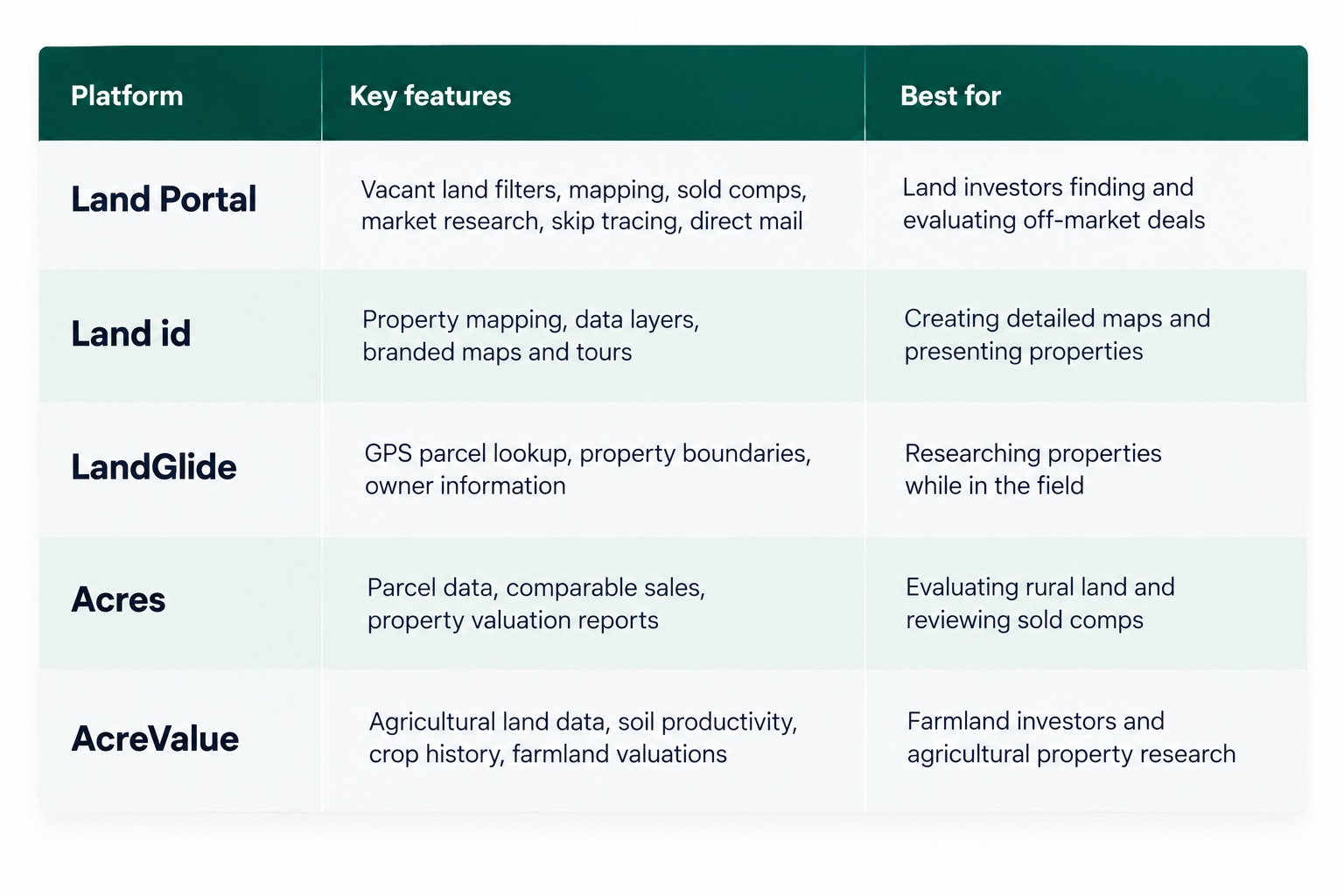
Each platform serves a slightly different purpose. The best alternative depends on what you’re trying to accomplish beyond viewing parcel information.
What Does Regrid Offer?
Before comparing alternatives, it’s worth understanding what Regrid already does well.
Regrid provides nationwide parcel mapping and property data, making it useful for identifying properties, researching ownership, and viewing parcel boundaries.
Its Property App includes features such as:
Nationwide parcel maps and property information
Ownership and mailing address records
Property search and lookup tools
Flood hazard, wetlands, and contour mapping layers
Offline mapping capabilities for fieldwork
Property data downloads and exports
For someone researching individual properties or looking up ownership information, Regrid can be a practical option.
However, land investors who regularly build acquisition lists, evaluate comparable sales, or contact property owners may need additional capabilities.
That’s where the following alternatives come in.
1. Land Portal: Best for Finding and Evaluating Land Deals
Land Portal is designed specifically for land investors, combining nationwide property data with tools for finding, researching, valuing, and contacting landowners.
While Regrid is primarily focused on parcel data and mapping, Land Portal supports more of the land acquisition process.
Instead of simply locating a property, investors can use land-specific filters to identify potential opportunities and evaluate them before making an offer.
Key features include:
Vacant Land AI: Identify properties likely to be vacant.
Road Frontage AI and Landlocked filters: Screen for potential access concerns.
Wetlands, FEMA, and slope tools: Research environmental and terrain characteristics.
Nationwide MLS data: Review active and sold land listings.
LP Estimate and AI Comp Reports: Estimate property values using comparable sales.
Market Research: Compare inventory, sold activity, days on market, and price per acre.
Skip tracing and Mail Center: Find available owner contact information and send direct mail.
Land Portal is particularly useful for investors who regularly search multiple counties, build targeted lists, and contact landowners about potential purchases.
The platform also offers Saved Maps for organizing and sharing property research.
Best for: Land investors who want property research, valuation, and owner outreach tools in one platform.
Pricing: Monthly subscription options are available, with features varying by plan. See Land Portal’s current pricing.
2. Land id: Best for Property Mapping and Presentations
Land id is a property mapping platform offering nationwide parcel information and detailed geographic data.
Its mapping tools are useful for researching land, but the platform also offers features designed to help users present properties to other people.
For example, branded property maps and tours can help buyers understand a property’s location, boundaries, surrounding terrain, and other characteristics.
Key features include:
Interactive parcel mapping
Nationwide property and ownership information
Multiple map layers and basemaps
Branded property tours
Shareable and embeddable maps
Comparable sales reports on eligible plans
Land id can be particularly useful for landowners, real estate agents, and investors who want to create professional property presentations.
However, investors focused on building acquisition lists and contacting large numbers of landowners may need additional tools.
Best for: Investors and real estate professionals who prioritize mapping and presenting properties to potential buyers.
Pricing: See Land id’s plans and pricing.
3. LandGlide: Best for Looking Up Properties in the Field
LandGlide is a parcel mapping application designed for researching properties using GPS.
It’s particularly useful when you’re physically visiting land and want to identify nearby parcel boundaries or look up ownership information.
The platform offers mobile and desktop access, making it convenient for field research.
Key features include:
GPS-based parcel lookup
Property boundary maps
Ownership and mailing address information
Parcel acreage and available sales information
Property bookmarks and notes
Offline functionality
For investors visiting rural properties, LandGlide can help identify which parcel they’re looking at and provide useful property information while on-site.
However, GPS parcel maps should not be treated as legal surveys, and the platform is not primarily designed for building acquisition campaigns or calculating land offers.
Best for: Investors, agents, and land professionals who regularly visit properties and need mobile parcel mapping.
Pricing: See LandGlide’s current pricing.
4. Acres: Best for Land Comps and Property Research
Acres provides land mapping, property data, and valuation tools for researching rural properties.
While it shares some mapping capabilities with Regrid, Acres places additional emphasis on comparable sales and property valuation.
Its paid plans include features such as:
Parcel maps and ownership information
Courthouse and curated sold land comps
Property valuation reports
Flood, elevation, and soil mapping
Property search and research tools
Additional lead list options
For investors evaluating rural land, access to relevant comparable sales can be particularly useful when determining what to offer.
Acres can also appeal to landowners, brokers, and other professionals who need property information alongside valuation research.
Best for: Investors and land professionals who want property mapping with sold comps and valuation reports.
Pricing: Comparable sales and valuation features vary by subscription. See Acres pricing.
5. AcreValue: Best for Farmland and Agricultural Land
AcreValue focuses heavily on agricultural property research.
In addition to parcel information and comparable sales, it provides data related to soil productivity, crop history, and farmland values.
These factors can be especially important when evaluating agricultural properties, where productive capacity may influence land value.
Key features include:
Agricultural parcel information
Soil productivity data
Crop history
Farmland valuation information
Comparable sales
Property reports and mapping tools
AcreValue is particularly useful for investors who purchase farmland or evaluate agricultural properties.
However, someone primarily flipping small residential lots or recreational vacant land may have different research priorities.
Best for: Farmland buyers, agricultural landowners, and investors researching agricultural property values.
Pricing: AcreValue offers multiple subscription options, with some advanced features available by subscribed state. See AcreValue pricing.
What Should Land Investors Look for in a Regrid Alternative?
The right platform depends on what you’re currently missing from your property research process.
Here are five important considerations.
1. Land-Specific Property Filters
Parcel data tells you where a property is located, but it doesn’t necessarily tell you whether that property fits your investment criteria.
For vacant land investors, filters for acreage, vacant land status, road frontage, landlocked parcels, wetlands, flood zones, and slope can make property searches more targeted.
The ability to filter properties before reviewing them individually is particularly useful when researching entire counties.
2. Comparable Sales and Property Valuation
If you’re planning to make offers on land, you’ll need more than ownership records and parcel boundaries.
Recent sold comps help investors estimate market value and determine potential purchase prices.
Look for platforms that provide actual sold transactions, allow you to compare similar properties, and make it easy to review the information behind an estimate.
Automated valuations can be useful starting points, but they shouldn’t replace reviewing relevant comparable sales.
3. Owner Information and Outreach Tools
Many land investors find deals by contacting owners of off-market properties.
While parcel databases often provide owner names and mailing addresses, additional tools may be needed to locate phone numbers, export acquisition lists, or send direct mail.
For example, Land Portal includes skip tracing with Do Not Call (DNC) and litigator scrubbing, along with a Mail Center for sending standard letters and real handwritten mail.
If calling or texting owners, investors should also review applicable contact regulations. The FTC provides guidance on Do Not Call requirements.
4. Mapping and Due Diligence
Property mapping remains important even when using software with more advanced investing features.
Flood zones, wetlands, slope, and road access can all influence a property’s usability and potential resale value.
Look for mapping tools that make these conditions easy to identify.
Keep in mind that map overlays are intended for preliminary research. Important findings may still require verification through official records or professional evaluations.
5. Total Cost and Subscription Features
The cheapest subscription isn’t always the most cost-effective option.
Some platforms charge separately for property exports, comparable sales, skip tracing, or additional data.
Before subscribing, consider how frequently you’ll use the software and what features you’ll actually need.
A platform that costs more per month but includes the research tools you regularly use may offer better value than paying for several separate services.
Which Regrid Alternative Should You Choose?
The best choice comes down to how you use property data.
Choose Land Portal if you’re actively investing in vacant land and want tools for finding properties, researching market values, evaluating potential issues, and contacting owners.
Choose Land id if your priority is creating detailed property maps and presentations for buyers or clients.
Choose LandGlide if you frequently visit properties and need GPS-based parcel information in the field.
Choose Acres if you’re focused on rural property research and want access to comparable sales and valuation reports.
Choose AcreValue if you’re primarily evaluating farmland and agricultural properties.
And if all you need is a convenient way to view parcel boundaries and ownership information, Regrid may already provide what you’re looking for.
The goal isn’t necessarily to replace Regrid with a platform that has more features. It’s to choose software that supports the type of land research and investing you actually do.
The Bottom Line
Regrid is a useful starting point for property mapping and parcel research.
But for active land investors, identifying a parcel is often just the first step.
You still need to understand the property’s value, evaluate potential concerns, and determine how to contact the owner.
That’s where more specialized land investing software can help.
If you’re looking for a platform that combines nationwide property data, land-specific filters, comparable sales, and owner outreach, explore Land Portal’s plans and start your 7-day free trial.
Frequently Asked Questions
What is the best Regrid alternative for land investors in 2026?
It depends on your goals. Land Portal is a strong option for investors who want to find, evaluate, and contact landowners.
Land id focuses on property mapping and presentations, LandGlide is useful for field research, Acres offers land comps and valuation tools, and AcreValue specializes in agricultural property research.
How much do Regrid alternatives cost?
Pricing varies depending on the platform and subscription plan. Some offer relatively inexpensive parcel lookup tools, while others charge more for comparable sales, advanced filters, and acquisition features.
Check each provider’s pricing page and account for additional data or usage charges.
Do I need MLS comps if I already have parcel data?
If you’re buying or selling land, comparable sales are extremely useful. Parcel data helps identify a property’s location, ownership, and characteristics, while sold comps help estimate what similar properties have actually sold for.
How many properties do Regrid and its alternatives cover?
Several platforms offer nationwide parcel coverage, but record counts and available information vary. Regrid, Land Portal, and LandGlide all provide extensive U.S. parcel datasets.
More important than the total record count is whether a platform offers accurate, useful information in your target counties.
Does it matter where a land data platform is based?
Not necessarily. What’s more important is whether the platform provides reliable property information, relevant comparable sales, and the mapping or outreach features you need in the markets where you invest.
Your Premium Source For Real Estate Data
© Copyright 2026 Land Portal – All Rights Reserved