


Log in
Why Land Data Providers Show Different Records for the Same Property
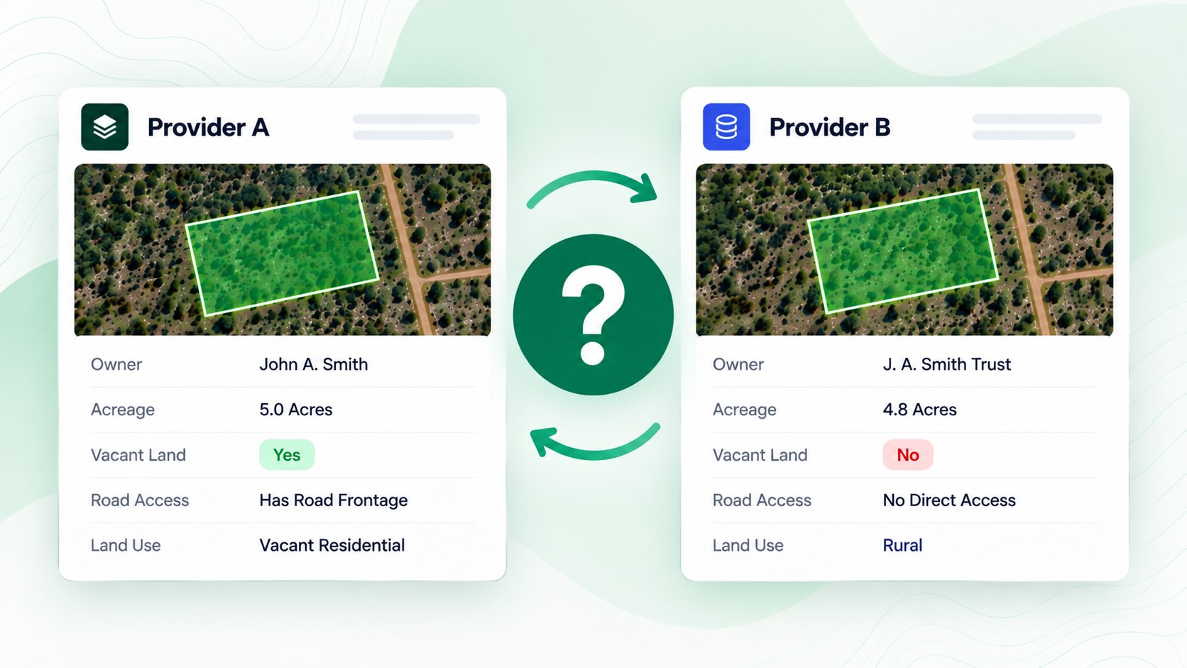
Have you ever looked up a property on two different land data platforms and noticed that the information doesn’t match?
One platform might show a different owner. Another might classify the property as vacant, even though a second platform doesn’t. You might even find different acreage, road access information, or phone numbers for the same parcel.
That doesn’t necessarily mean one platform is wrong.
Land data comes from multiple sources, and those sources don’t always update at the same time. Each provider also processes and organizes that information differently.
Understanding why these differences happen can help land investors make better decisions, avoid outdated property information, and know what to verify before making an offer.
Where Does Land Parcel Data Come From?
Most property data starts with local government records.
When a property changes hands, the deed is typically recorded with the county recorder or clerk. The county assessor then updates its ownership information based on the recorded documents.
For example, Gunnison County, Colorado explains that its assessor relies on documents filed with the county Clerk and Recorder to update ownership records.
But that information doesn’t instantly appear in every property database.
Land data providers collect records from thousands of local offices across the country. Each provider has its own process for gathering, updating, and organizing those records.
That creates the first opportunity for differences.
Two platforms can pull information from the same county and still show different results simply because they received the updates at different times.
Why Do Property Ownership Records Differ?
Ownership information is one of the most common differences investors encounter when comparing property databases.
When someone purchases land, the new owner’s name may not appear immediately in the county assessor’s records.
How long that takes depends on the county.
For example:
Maricopa County, Arizona: The assessor reports that standard ownership updates can take approximately 4–8 weeks after recording, with some property splits and other transactions taking longer.
Miami-Dade County, Florida: Ownership transfers typically take 4–8 weeks to process but may take up to 12 weeks.
Gunnison County, Colorado: The assessor aims to update ownership records within two weeks during most months, although delays can occur.
These timelines come from the respective county offices, including the Maricopa County Assessor and Miami-Dade Property Appraiser.
There’s another important distinction: the owner shown on a tax bill isn’t always the current owner.
For example, South Hadley, Massachusetts explains that property taxes are assessed based on ownership as of January 1, which can cause tax records to display a previous owner’s name after a sale.
For land investors, this matters when building acquisition lists.
If a property recently sold, one platform might show the new owner while another still displays the previous owner’s information.
What to do: If ownership information looks questionable, especially after a recent sale, check the county’s recorded deed or other official ownership records before contacting the owner.
The goal isn’t to independently verify every detail on every property you search.
It’s to know which information needs additional confirmation before you make a significant financial commitment.
Why Does One Platform Show Vacant Land and Another Doesn't?
Not every data provider determines vacant land status the same way.
Some rely heavily on county land-use classifications. Others combine property records with aerial imagery and additional analysis.
The problem is that county land-use codes weren’t necessarily designed to tell investors whether a parcel is completely free of structures.
For example, the Alameda County Assessor explains that its property use codes were created for assessment purposes.
Some categories described as vacant can still include miscellaneous improvements.
That means a property classified as vacant in county records isn’t automatically guaranteed to be empty.
Aerial Imagery Can Also Be Outdated
Aerial imagery provides another way to evaluate whether a parcel contains structures, but the imagery itself may not reflect current conditions.
The U.S. Geological Survey describes the National Agriculture Imagery Program (NAIP), which collects aerial imagery on a recurring cycle.
If someone builds a structure after an image was captured, that development may not appear until newer imagery becomes available.
As a result, two platforms can show different vacant land classifications because they’re using different records, imagery, or methods of analyzing the property.
What to do: Use vacant land filters to narrow your search, but verify the properties you’re seriously considering through current imagery, available records, or an on-site inspection.
Why Do Parcel Boundaries and Road Access Information Differ?
Parcel boundaries and road access are particularly important when evaluating vacant land.
But just because a property appears to touch a road on a map doesn’t necessarily mean it has legal access.
Different providers may use different mapping datasets or update those datasets at different times.
Even small differences in parcel boundaries or road locations can affect whether a property appears to have road frontage.
The U.S. Census Bureau explains that its TIGER/Line geographic boundaries are intended for statistical purposes and do not establish legal ownership rights.
The same general caution applies when evaluating parcel maps.
A road frontage or landlocked indicator is a useful starting point, not legal proof of access.
Before purchasing land, investors should verify important access questions through recorded deeds, easements, surveys, or the appropriate local authorities.
Why Do Skip Tracing Results Show Different Phone Numbers?
Property ownership records typically provide an owner’s name and mailing address, but they don’t always include phone numbers or email addresses.
That’s why land investors often use skip tracing.
Skip tracing services gather available contact information from additional data sources and attempt to match it to property owners.
However, those sources don’t always contain the same information.
One provider might return a phone number that another doesn’t. Some numbers may be outdated, while others may belong to someone previously associated with the owner.
A Federal Trade Commission report on data brokers highlights how consumer information can pass through multiple data sources and companies, making it difficult to trace and correct inaccuracies.
Although the report wasn’t specifically about land investing, it helps explain why contact information can vary between services.
What to do: Don’t assume every skip-traced number or email address is accurate. Compare results when necessary, use available contact screening tools, and follow applicable outreach regulations.
Where Land Data Providers Can Show Different Information
Here’s a quick breakdown of the most common differences and what land investors should verify.
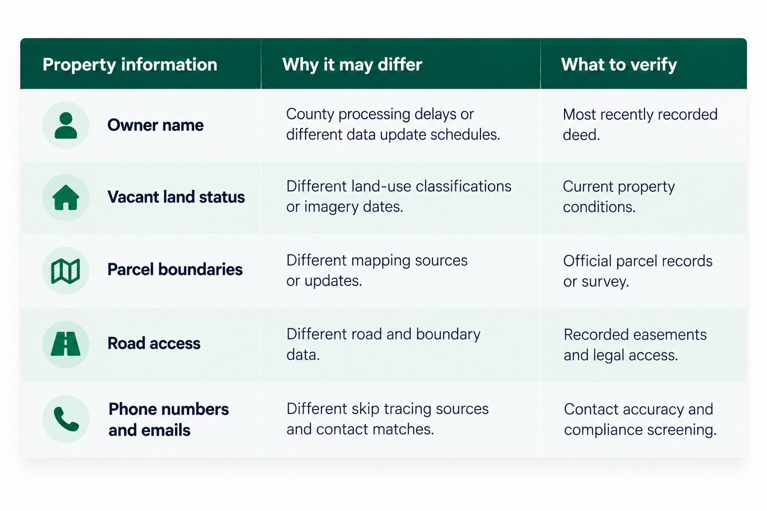
The important takeaway is that property data can vary for several reasons, and each type of information may require a different verification method.
How Can You Tell Which Land Data Provider Is More Reliable?
There isn’t one database that will always have the most accurate information for every parcel.
Even official county records can take time to reflect recent transactions, and different datasets within the same platform may update on different schedules.
Instead of focusing entirely on which provider claims to have the most records, consider how useful and verifiable its information is.
Here are four practical ways to evaluate a platform.
1. Compare Properties You Already Know
Choose a few properties you’ve researched before, ideally including some that recently sold.
Look them up on each platform and compare the owner name, acreage, vacant status, and other important details.
This gives you a practical way to evaluate how the platforms perform in markets you actually invest in.
2. Understand Where the Information Comes From
Look for providers that explain their underlying data sources.
Ownership information, parcel boundaries, environmental overlays, and phone numbers may all come from different sources.
Knowing where information originates helps you understand what it can and cannot confirm.
3. Consider How Frequently Data Is Updated
Not every dataset updates at the same time.
Ownership records may change after a recorded sale, while aerial imagery and other mapping information may follow entirely different schedules.
Ask how a provider handles updates rather than assuming every field is refreshed simultaneously.
4. Use Filters for Research, Then Verify Important Details
Property filters can save substantial time when researching hundreds or thousands of parcels.
However, filters should help you identify properties worth investigating, not replace due diligence.
Before making an offer, verify important information such as ownership, access, property conditions, and comparable sales.
How Land Portal Handles Property Data
Land Portal brings together nationwide property records, MLS data, mapping information, environmental datasets, and AI-powered research tools specifically for land investors.
Instead of relying on basic parcel information alone, investors can evaluate properties using tools such as:
Vacant Land AI: Identify properties likely to be vacant.
Road Frontage AI and Landlocked filters: Screen for potential access concerns.
Wetlands, FEMA, and slope tools: Evaluate important property characteristics.
Nationwide MLS data and LP Estimate: Research comparable sales and potential property values.
Skip tracing: Find available owner phone numbers and email addresses with DNC and litigator scrubbing.
Land Portal updates its property data as information becomes available, although update timing varies depending on the underlying source.
As with any property research platform, important findings should still be verified before making a purchase.
You can learn more about the platform’s data sources and coverage on the Land Portal Data page.
The Bottom Line
When two land data providers show different records for the same parcel, the difference often comes down to when the information was collected, where it originated, and how the provider processed it.
Ownership records can take weeks to update. Vacant land classifications may rely on different county codes or aerial imagery. Mapping data can vary, and skip tracing services don’t always return the same contact information.
For land investors, the goal isn’t to find a database that never has discrepancies.
It’s to use reliable research tools, understand what the information tells you, and verify the details that matter before making an offer.
If you’re looking for land-specific property research, mapping, comparable sales, and owner information in one platform, explore Land Portal’s plans and start your 7-day free trial.
Frequently Asked Questions
Do all land data providers use the same county records?
Many providers collect information from the same county assessor and recorder offices, but they may retrieve updates at different times or organize the information differently. That’s why two platforms can show different details for the same property.
How long does it take for a new owner to appear in property records?
It depends on the county. Some offices aim to update ownership records within a couple of weeks, while others report processing times of 4–8 weeks or longer. A land data provider’s own update schedule can add additional time.
Why would a vacant land filter miss a property or include one with a structure?
Vacant land classifications can depend on county land-use codes, aerial imagery, and how the provider analyzes the data. Some county categories described as vacant may still allow improvements, while older imagery may not show recent construction.
Does road frontage on a map guarantee legal access?
No. A parcel appearing to touch a road doesn’t automatically establish legal access. Investors should review recorded deeds, easements, and other relevant documents before relying on a road frontage or landlocked classification.
Why do skip tracing services return different phone numbers?
Skip tracing providers may use different contact data sources and matching methods. Some information can be outdated or incorrectly associated with a property owner. Investors should verify contact information when necessary and follow applicable outreach regulations.
Your Premium Source For Real Estate Data
© Copyright 2026 Land Portal – All Rights Reserved